
When people imagine drilling a well, they often picture a drill bit traveling straight downward beneath a rig. That was once the standard approach for many wells, but modern drilling systems can do something far more sophisticated: they can steer a wellbore underground.
This technique is known as directional drilling. 🧭
Directional drilling allows engineers to intentionally change the angle and direction of a well as it moves through rock. Instead of drilling only vertically beneath the rig, the well can curve, travel horizontally, and reach targets located hundreds or even thousands of meters away from the surface location.
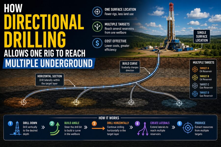
This capability makes it possible for one drilling site or rig location to access multiple underground targets, greatly reducing the amount of land and infrastructure required at the surface.
Directional drilling is widely used in oil and gas production, geothermal energy, mining, utility installation, and other subsurface engineering projects.
⛏️ Why Not Just Drill Straight Down?
Vertical drilling works well when the underground target is directly beneath the drilling rig.
But many geological formations are not conveniently located that way.
An oil-bearing reservoir may extend sideways beneath:
- A city
- A lake
- A protected ecosystem
- A mountain
- An offshore area
- Existing infrastructure
Moving an entire drilling operation directly above every target may be impractical, expensive, or environmentally disruptive.
Directional drilling solves the problem by allowing the well to begin at one surface location and then curve toward the desired underground destination.
It is similar to entering a highway from one location and then taking different routes toward several destinations. 🛣️
🏗️ One Surface Pad, Many Wells
A major advantage of directional drilling is pad drilling.
Instead of building a separate drilling site for every well, operators can construct one larger surface pad.
A drilling rig on that pad can drill several wells in different underground directions.
From the surface, the wellheads may be only a few meters apart.
Deep underground, however, those wells can spread outward like the spokes of a wheel. 🕸️
One well may travel north.
Another may curve east.
Another might extend southwest.
Each well can target a different part of the same reservoir—or even different geological formations.
This approach greatly reduces the number of access roads, pipelines, power connections, and drilling locations required.
📍 How Engineers Decide Where the Well Should Go
Directional drilling begins long before the drill bit enters the ground.
Geologists and geophysicists study the underground formation using information from:
- Seismic surveys
- Previous wells
- Geological maps
- Rock samples
- Reservoir models
Engineers then identify specific underground locations known as targets.
A target may represent a productive section of an oil reservoir, a geothermal zone, or another geological feature.
Once the target is selected, drilling engineers design a three-dimensional path from the surface location to the target.
This planned route is called the well trajectory.
📐 Inclination and Azimuth
Two measurements are especially important when describing a directional well:
Inclination describes how far the well deviates from vertical.
A perfectly vertical well has an inclination of approximately:
0°
A horizontal well has an inclination near:
90°
Azimuth describes the compass direction in which the well is heading.
For example, a well might travel northeast at a particular inclination.
Together, inclination and azimuth allow engineers to describe the three-dimensional orientation of the wellbore. 🧭
By measuring these values repeatedly during drilling, the team can determine whether the drill bit is following the intended trajectory.
🔄 The Kickoff Point
Most directional wells begin by drilling vertically.
At a predetermined depth, engineers begin intentionally steering the well away from vertical.
This location is called the kickoff point, or KOP.
Below the kickoff point, the well gradually develops angle.
The drilling team carefully controls how quickly the inclination changes.
An overly sharp curve could place excessive stress on drill pipe, casing, and other equipment.
Therefore, the well usually follows a smooth path rather than making an abrupt turn.
📈 Build, Hold, and Drop Sections
A directional well trajectory often contains several basic sections.
During a build section, the well’s inclination gradually increases.
During a hold section, the inclination remains approximately constant while the well continues traveling in the desired direction.
In some designs, a drop section reduces inclination again.
A simplified trajectory might look like:
Vertical → Build angle → Hold angle → Reach target
A horizontal well may continue building until it reaches nearly 90° inclination and then travel laterally through the reservoir.
These shapes allow drilling engineers to reach targets located far away from the rig.
⚙️ How Can a Drill Bit Actually Turn Underground?
At first, steering a long steel drill string through solid rock sounds impossible.
The key is specialized downhole drilling equipment.
One traditional method uses a bent housing combined with a downhole motor.
The lower drilling assembly is intentionally angled slightly.
When the drill string is held in a particular orientation and the downhole motor rotates the bit, the well tends to curve in the direction of the bend.
Once the desired angle has been achieved, the entire drill string can rotate again, causing the drilling assembly to average out the bend and drill more nearly straight.
This process is sometimes associated with slide drilling.
🌪️ Mud Motors
A mud motor is a downhole motor powered by drilling fluid.
Drilling fluid—commonly called drilling mud—is pumped down through the drill pipe.
The moving fluid turns internal components in the motor, causing the drill bit to rotate.
This means the drill bit can continue spinning even when the main drill string at the surface is not rotating.
That capability is especially useful during directional steering.
The drilling crew can orient the bent motor in the desired direction and let the downhole motor drive the bit forward.
🤖 Rotary Steerable Systems
Modern directional wells increasingly use advanced equipment called rotary steerable systems, or RSS.
Unlike traditional slide drilling, rotary steerable systems can steer the well while the drill string continues rotating.
The system makes small controlled adjustments near the drill bit to influence its direction.
This offers several advantages.
Continuous rotation can improve:
- Hole quality
- Drilling speed
- Cuttings removal
- Directional accuracy
- Wellbore smoothness
Some rotary steerable systems use sophisticated electronics and automated control methods to follow complex well trajectories with remarkable precision. 🤖
📡 Measuring While Drilling
Engineers cannot see the drill bit directly once it is thousands of meters underground.
Instead, they rely on specialized instruments.
Measurement While Drilling, or MWD, systems measure the orientation and behavior of the drilling assembly while the well is being drilled.
Typical measurements can include:
- Inclination
- Azimuth
- Tool orientation
- Temperature
- Pressure
- Vibration
These measurements help determine the exact position and direction of the well.
Some information can be transmitted back to the surface in real time.
🪨 Logging While Drilling
Another technology known as Logging While Drilling, or LWD, collects information about the surrounding rock.
LWD tools can measure geological properties such as:
- Natural radioactivity
- Electrical resistivity
- Density
- Porosity
- Acoustic characteristics
These measurements help geologists determine whether the well is inside the desired reservoir interval.
This is especially important during horizontal drilling.
If the productive layer is only a few meters thick, the drilling team must keep the well inside that zone for potentially thousands of meters.
🎯 Geosteering Keeps the Well Inside the Best Rock
The process of adjusting a well trajectory based on real-time geological measurements is known as geosteering.
Imagine a productive rock layer that bends and changes thickness underground.
A preplanned straight horizontal path might eventually leave the best part of the formation.
With geosteering, engineers compare real-time measurements with geological models.
If the reservoir begins dipping downward, they can steer the well downward.
If it rises, they can adjust upward.
This allows the well to follow the most valuable portion of the formation instead of simply following a fixed geometric path. 🎯
🌳 How One Rig Reaches Multiple Targets
A single drilling rig does not normally split one ordinary well into dozens of branches automatically.
Instead, the rig often drills multiple separate directional wells from the same pad.
After completing one well, the rig can be moved a short distance across the pad to another wellhead position.
Specialized rigs may even “walk” or skid between nearby well slots without being completely dismantled.
Each well begins near the same surface area but follows its own underground trajectory.
The resulting pattern can resemble an underground tree or fan.
This approach can expose a very large reservoir area while keeping surface development concentrated.
🌿 Multilateral Wells
In some cases, engineers do create multiple underground branches from a single main wellbore.
These are known as multilateral wells.
A main bore may descend from the surface and then divide into two or more lateral branches.
Each branch can access a different section of the reservoir.
Multilateral wells can reduce the amount of duplicated well infrastructure required.
However, they are technically more complex.
Engineers must carefully design junctions, completion equipment, flow control, and future maintenance access.
↔️ Horizontal Drilling
Horizontal drilling is one of the most important applications of directional drilling.
A horizontal well begins vertically or at a moderate angle and gradually curves until the wellbore is nearly parallel to the underground formation.
The well then continues laterally through the reservoir.
Why is this valuable?
Suppose a productive rock layer is only 20 meters thick but extends for several kilometers horizontally.
A vertical well might contact only about 20 meters of that layer.
A horizontal well could remain inside the formation for 1,000, 2,000, or even more meters.
That dramatically increases contact between the well and the reservoir. 📏
🛢️ Greater Reservoir Contact
The amount of reservoir rock exposed to the wellbore can strongly influence production.
More contact provides more pathways for fluids to enter the well.
Horizontal and directional wells can therefore improve recovery from formations where vertical wells would have limited exposure.
This is particularly useful in:
- Thin reservoirs
- Fractured formations
- Low-permeability rock
- Heavy-oil deposits
- Complex offshore reservoirs
Directional drilling does not automatically guarantee higher production, but it gives engineers much greater flexibility in how the reservoir is accessed.
🌊 Offshore Drilling Platforms
Directional drilling is especially important offshore.
Building a separate offshore platform directly above every underground target would be extremely expensive.
Instead, one platform can host many wells.
The wells begin close together at the platform and then spread outward underground.
Some may extend several kilometers away from the platform.
This allows one offshore facility to access a large area of reservoir beneath the seafloor. 🌊
Without directional drilling, offshore field development would often require far more surface infrastructure.
🏙️ Reaching Beneath Sensitive Areas
Directional drilling also allows engineers to avoid placing equipment directly above a target.
For example, a reservoir might extend beneath:
- Wetlands
- Residential areas
- Rivers
- Protected habitats
- Existing industrial facilities
A well can begin outside the sensitive area and curve underneath it.
This does not eliminate every environmental impact associated with drilling, but it can significantly reduce the physical surface footprint required to access underground resources.
📉 Smaller Surface Footprint
If ten wells each required their own separate drilling site, the project could need ten pads, multiple roads, and extensive infrastructure.
With directional pad drilling, those wells may begin from one concentrated location.
That can reduce:
- Land disturbance
- Road construction
- Pipeline length
- Utility installation
- Equipment relocation
- Habitat fragmentation
It can also simplify logistics because workers, drilling equipment, and services remain concentrated in one area.
💰 Lower Development Costs
Drilling directional wells requires sophisticated technology, but pad-based development can reduce many other costs.
Building drilling sites is expensive.
So are roads, electrical connections, water handling systems, pipelines, and moving large rigs.
By drilling multiple wells from one pad, operators can share infrastructure.
This can reduce the cost per well and make some projects economically practical that would otherwise require too much surface construction.
🧲 Keeping Wells from Colliding
When many wells originate from one pad, avoiding underground collisions becomes extremely important.
Imagine dozens of wellbores spreading outward from nearly the same location.
Engineers use anti-collision planning to maintain safe separation between them.
Survey measurements from existing wells are incorporated into three-dimensional models.
Software calculates both the estimated location of each well and the uncertainty surrounding that location.
The new trajectory is then designed to maintain adequate separation.
Directional drilling therefore combines mechanical drilling with sophisticated geometry and surveying. 📐
🛰️ How Underground Position Is Calculated
A drilling system generally cannot rely on GPS once it is deep underground because satellite signals do not penetrate thousands of meters of rock.
Instead, engineers estimate the well’s position using downhole survey measurements.
At many points along the well, instruments measure inclination and azimuth.
Software combines those measurements with the measured distance traveled along the wellbore.
By integrating the successive survey measurements, the system calculates the three-dimensional path of the well.
Highly accurate surveys are essential when targets are small or neighboring wells are nearby.
🪨 Drilling Fluid Does More Than Power the Bit
Drilling fluid plays several critical roles during directional drilling.
It can:
- Cool and lubricate the drill bit
- Carry rock cuttings to the surface
- Help control underground pressure
- Stabilize the wellbore
- Power downhole mud motors
- Carry information from downhole instruments in some systems
In long horizontal sections, moving cuttings out of the well can become especially challenging.
Engineers carefully control fluid flow and drill-string rotation to prevent cuttings from accumulating.
📏 Dogleg Severity
Engineers measure how quickly a well changes direction using a quantity known as dogleg severity.
It describes the rate at which inclination and/or azimuth change over a specified wellbore distance.
A very sharp directional change creates higher mechanical stresses.
Drill pipe, casing, production tubing, and downhole tools all need to pass through the curved well.
Excessive curvature can increase friction and make equipment difficult to install or retrieve.
Therefore, directional trajectories are designed with smooth, controlled bends.
🧲 Torque and Drag
A long directional well creates much more contact between the drill string and the wellbore wall than a simple vertical well.
This produces torque and drag.
Drag resists movement when the drill string is pushed or pulled.
Torque resists rotation.
As horizontal sections become longer, these forces can become major engineering limitations.
Drilling engineers model torque and drag before and during drilling to determine whether the planned well can be drilled and completed safely.
🌍 Extended-Reach Drilling
Some advanced directional wells are classified as extended-reach wells.
These wells travel extraordinarily long horizontal distances relative to their vertical depth.
Extended-reach drilling allows operators to access remote targets from a single location.
However, longer wells introduce challenges including:
- Greater friction
- More difficult cuttings transport
- Higher mechanical loads
- Complex pressure management
- Increased survey requirements
Successfully drilling such wells requires careful planning and highly specialized equipment.
♨️ Directional Drilling in Geothermal Energy
Directional drilling is not limited to oil and gas.
Geothermal projects can also use directional wells to access hot underground rock and fluid systems.
Several wells may be drilled from one surface site to intercept different parts of a geothermal reservoir.
Directional drilling can also help position injection and production wells at carefully selected distances from one another.
As advanced geothermal technologies develop, accurate subsurface steering is becoming increasingly valuable. ♨️
🚇 Utility and Infrastructure Drilling
A related technique called horizontal directional drilling, or HDD, is widely used for installing underground infrastructure.
Utilities can drill beneath:
- Roads
- Rivers
- Railways
- Buildings
- Environmentally sensitive areas
A pilot hole is steered along a planned path.
The hole is then enlarged, and a pipe or conduit is pulled through.
This allows utilities to install water lines, gas pipelines, electrical conduits, or communications cables without digging an open trench across the entire route. 🚧
Although HDD equipment differs from deep petroleum directional drilling, both technologies rely on the ability to steer a bore underground.
🔬 Real-Time Data Makes Modern Drilling Possible
Modern directional drilling is increasingly data-driven.
Engineers at the surface can monitor information arriving from downhole tools while drilling continues.
They may observe:
- Well direction
- Formation characteristics
- Drilling speed
- Downhole pressure
- Tool vibration
- Bit behavior
This allows decisions to be made rapidly.
If the well begins drifting away from its target, corrections can be applied.
If geological measurements indicate better rock nearby, the trajectory may be modified.
Directional drilling is therefore not simply mechanical steering—it is a continuous combination of measurement, interpretation, and control. 💻
⚠️ Directional Drilling Has Limitations
The technology provides major advantages, but it also increases complexity.
Directional wells may require:
- More expensive downhole tools
- Detailed trajectory planning
- Precise surveying
- Skilled directional drillers
- Advanced drilling software
- Greater torque-and-drag management
Equipment failures can also be more difficult to address in long, highly deviated wells.
A horizontal tool thousands of meters from the surface can be much harder to retrieve than equipment in a simple shallow vertical well.
🔧 Completing a Directional Well
Reaching the target is only part of the job.
After drilling, the well may need casing, cement, production tubing, valves, or other completion equipment.
All of this equipment must travel through the curved wellbore.
This is another reason trajectories cannot contain excessively sharp bends.
Completion engineers work closely with drilling teams to ensure the final well geometry can accommodate the equipment required for safe long-term operation.
🌐 Why One Rig Can Access Such a Large Underground Area
The most important concept is that surface location and underground location do not have to be the same.
A drilling rig may occupy only a small area on the surface.
But each well can travel outward in a different direction.
If many directional wells are drilled from the same pad, their underground coverage can extend across a broad region.
Viewed from above, the wells may form a fan-like pattern.
Viewed from the side, some may remain moderately angled while others curve into long horizontal sections.
That geometry allows one surface site to reach an underground area far larger than the site itself. 🗺️
✅ The Bottom Line
Directional drilling allows engineers to steer wells through the subsurface instead of drilling only vertically.
By controlling inclination and azimuth, drilling teams can guide a well toward targets located far from the rig.
Technologies such as mud motors, rotary steerable systems, Measurement While Drilling, Logging While Drilling, and geosteering allow the trajectory to be monitored and adjusted while drilling is underway.
From a single drilling pad, multiple wells can fan outward toward different parts of a reservoir. Some projects may even use multilateral wells with several underground branches.
This approach can increase reservoir contact, reduce surface infrastructure, lower development costs, and allow drilling beneath areas where placing a rig directly above the target would be impractical.
Directional drilling has transformed subsurface engineering by separating one simple idea from another:
Where a well starts does not determine where it has to end. 🧭🛢️
A rig sitting on one compact patch of land can guide wells kilometers away underground, turning a single surface location into a gateway to many different subsurface targets.