
Oil and natural gas can exist several kilometers beneath the Earth’s surface, hidden inside tiny pores within rock formations that may be completely invisible from above. Yet engineers and geoscientists can often identify promising underground reservoirs without ever seeing them directly. 🌍🔍
They do this by combining geology, physics, seismic imaging, satellite data, well logging, computer modeling, and carefully planned drilling.
Finding hydrocarbons is therefore not simply a matter of “digging until oil appears.” It is a complex scientific investigation in which engineers gradually reduce uncertainty.
A typical exploration project asks several fundamental questions:
Was oil or gas generated here?
Did it migrate into a reservoir rock?
Is there a geological trap capable of holding it?
Is the reservoir large enough to develop economically?
Answering those questions may require years of study and large amounts of data.
🧬 Where Do Oil and Natural Gas Come From?
Oil and natural gas formed primarily from ancient organic material.
Millions of years ago, microscopic organisms such as algae and plankton lived in oceans and lakes. When they died, some of their remains settled on the bottom and became buried by layers of sediment.
If the buried organic material was protected from complete decay, increasing pressure and temperature gradually transformed it.
Over geological time, organic-rich sediment could become source rock.
With sufficient heat and burial, organic molecules changed into hydrocarbons.
Broadly speaking:
Organic matter → burial → heat and pressure → oil and natural gas
This transformation usually takes millions of years. ⏳
The resulting hydrocarbons can then migrate through underground rock until they become trapped.
🪨 Oil Is Usually Stored Inside Rock, Not Giant Underground Lakes
A common misconception is that petroleum exists in enormous hollow caverns beneath the ground.
Usually, it does not.
Most oil and gas are stored inside the microscopic pore spaces between grains of reservoir rock.
Imagine a sponge filled with water.
The sponge appears solid from the outside, but it contains countless connected spaces inside.
Porous rocks such as sandstone and some types of limestone can behave in a similar way.
Two important reservoir properties are:
🧽 Porosity
Porosity describes how much empty space exists within the rock.
A rock with high porosity can potentially hold a larger volume of fluids.
🌊 Permeability
Permeability describes how easily fluids can move through connected pores.
A reservoir can have significant porosity but poor permeability if those pores are not well connected.
Engineers need to understand both properties when evaluating an underground reservoir.
🧱 What Keeps Oil and Gas From Escaping?
Hydrocarbons are often less dense than the salty water present underground.
As a result, oil and gas tend to migrate upward through permeable formations.
Unless something stops them, they may eventually reach the surface and escape.
A useful petroleum accumulation therefore requires a trap.
The trap usually includes a layer of impermeable or very low-permeability rock called a seal or cap rock.
Common seal rocks include shale and salt.
A simplified underground petroleum system might contain:
Gas at the top
Oil beneath the gas
Water below the oil
with impermeable rock preventing the hydrocarbons from moving farther upward.
🏔️ Geological Structures Can Create Traps
Geologists look for underground structures where hydrocarbons may accumulate.
One common example is an anticline.
An anticline is an upward-arching fold in layers of rock.
If a porous reservoir rock is folded upward and covered by impermeable cap rock, oil and gas may become trapped near the top of the structure.
Other possible traps include:
- Fault traps
- Salt-related structures
- Stratigraphic traps
- Reef structures
- Pinch-outs
Finding these structures is one of the main goals of petroleum exploration. 🗺️
🧭 Geological Mapping Comes First
Before expensive surveys or drilling begin, exploration teams study the regional geology.
Geologists may examine:
- Rock formations exposed at the surface
- Geological maps
- Existing wells
- Fossils
- Sedimentary environments
- Structural geology
- Regional tectonic history
They try to reconstruct what the area looked like millions of years ago.
Was it once a shallow sea?
Was organic-rich sediment deposited there?
Were sandstone layers formed by ancient rivers?
Were the rocks buried deeply enough to generate hydrocarbons?
This regional understanding helps determine whether a petroleum system could exist at all.
🛰️ Satellites and Remote Sensing Help Map the Surface
Modern exploration can also use satellite imagery and aerial surveys.
Remote sensing can reveal:
- Fault patterns
- Surface structures
- Rock types
- Terrain
- Vegetation differences
- Geological lineaments
Satellite data usually cannot simply “see” a deep oil reservoir directly.
Instead, it provides information about the surface that may help geologists understand the deeper geological structure.
In some areas, gravity and magnetic surveys are also used to investigate broad underground features.
🧲 Gravity Surveys Reveal Density Differences
Different rocks have different densities.
A gravity survey measures extremely small variations in Earth’s gravitational field.
For example, a thick underground salt body has a different density from many surrounding rocks.
That density contrast can slightly affect the gravity measured at the surface.
Highly sensitive instruments can detect these variations.
Engineers can then construct models of the likely underground geology.
Gravity surveys are particularly useful for identifying large-scale structures before more detailed exploration begins.
🧭 Magnetic Surveys Detect Rock Properties
Magnetic surveys measure variations in Earth’s magnetic field caused by magnetic minerals in underground rocks.
They can help identify:
- Basement rock depth
- Major faults
- Regional structures
- Igneous formations
Like gravity surveys, magnetic measurements usually provide broad geological information rather than a direct image of an oil reservoir.
They are one piece of a much larger exploration puzzle. 🧩
🌊 Seismic Surveys Are One of the Most Powerful Exploration Tools
One of the most important technologies in modern oil and gas exploration is reflection seismology.
The basic principle resembles medical ultrasound.
A controlled energy source generates waves that travel downward through the Earth.
Whenever the waves encounter boundaries between rock layers with different physical properties, part of the energy reflects back toward the surface.
Sensitive instruments detect those returning waves.
By measuring how long the echoes take to return, geophysicists can estimate the depth and geometry of underground rock layers.
🔊 How Seismic Reflection Works
Suppose a seismic wave travels through one type of sandstone and reaches a layer of shale.
Because the two rocks have different acoustic properties, some of the wave continues deeper while some reflects upward.
Receivers record the reflected signal.
The travel time may be only a few seconds, but sophisticated computers can analyze enormous quantities of these measurements.
The basic process is:
Energy source → wave travels underground → reflection occurs → sensors record return → computer processes data
From those reflections, geoscientists build an image of underground structures. 💻🌍
🗺️ 2D and 3D Seismic Imaging
Older seismic surveys often produced two-dimensional cross sections of the subsurface.
Modern exploration frequently uses 3D seismic surveys.
Thousands of source and receiver locations are arranged across a large area.
Computers combine the measurements to construct a three-dimensional model of underground geology.
This allows exploration teams to visualize:
- Faults
- Rock layers
- Folded structures
- Possible reservoirs
- Salt formations
- Potential trapping geometries
A 3D seismic model can resemble a medical CT scan of the Earth—although the physics and processing methods are very different. 🧠📊
🌊 How Offshore Seismic Surveys Work
At sea, seismic surveys are commonly performed from specialized vessels.
The ship tows arrays of hydrophones behind it.
A controlled acoustic source sends energy into the water and seabed.
The waves travel through underground formations and reflect back.
Long strings of sensors record those returning signals.
Because offshore sedimentary basins can be buried beneath several kilometers of water and rock, seismic imaging is especially important for offshore exploration. 🚢
💻 Raw Seismic Data Must Be Heavily Processed
The signals recorded during a seismic survey do not immediately form a clear image.
Raw data may contain:
- Noise
- Multiple reflections
- Distorted travel paths
- Signals from different depths
- Effects caused by complex geology
Powerful computers process the measurements using mathematical algorithms.
Important operations can include:
- Filtering
- Velocity analysis
- Stacking
- Migration
- Noise reduction
The goal is to transform millions or billions of measurements into a geologically meaningful representation of the subsurface.
📐 Seismic Velocity Helps Estimate Depth
Seismic systems directly measure travel time, not depth.
To convert travel time into depth, geoscientists need to estimate how quickly seismic waves move through the underground rocks.
Different materials have different seismic velocities.
For example, waves generally travel at different speeds through:
- Loose sediments
- Sandstone
- Shale
- Limestone
- Salt
If the seismic velocity model is inaccurate, the estimated structure may appear at the wrong depth or shape.
Developing accurate velocity models is therefore an important part of seismic interpretation.
🧠 Engineers Build Geological Models
Seismic data is combined with geology to create a subsurface model.
These digital models may contain millions of cells representing underground formations.
Each region can be assigned properties such as:
- Porosity
- Permeability
- Rock type
- Pressure
- Fluid saturation
- Temperature
Geologists and reservoir engineers use these models to estimate how much oil or gas might exist and how fluids could move through the reservoir.
The model is updated whenever new information becomes available.
🛢️ Seismic Images Do Not Guarantee Oil
A geological structure may look extremely promising in seismic data and still contain little or no commercial petroleum.
Why?
Because a successful accumulation requires several conditions to occur together.
There must typically be:
- A source rock
- Hydrocarbon generation
- Migration pathways
- Reservoir rock
- A trap
- A seal
- Proper geological timing
If even one part of this system is missing, the prospect may fail.
This is why exploration remains uncertain even with sophisticated technology.
🎯 Choosing Where to Drill
After interpreting geological and seismic data, exploration teams identify possible drilling targets called prospects.
Engineers then evaluate factors such as:
- Estimated reservoir size
- Probability of hydrocarbons
- Reservoir depth
- Geological complexity
- Development difficulty
- Economic conditions
- Environmental constraints
A prospect may look promising, but drilling is often the only way to determine what is actually underground.
🛠️ Exploration Wells Provide Direct Evidence
An exploration well is drilled primarily to test whether a predicted reservoir really contains hydrocarbons.
As the well penetrates the Earth, engineers collect enormous amounts of information.
Drilling may reveal:
- Rock type
- Formation pressure
- Temperature
- Fluid composition
- Reservoir thickness
- Porosity
If hydrocarbons are discovered, additional wells may be drilled to determine the size and characteristics of the reservoir.
🪨 Drill Cuttings Reveal Underground Rock
As a drill bit breaks rock at the bottom of a well, drilling fluid carries small pieces of rock called cuttings back to the surface.
Geologists examine these samples.
They can identify:
- Rock type
- Grain size
- Mineral composition
- Fossils
- Hydrocarbon indications
The cuttings provide direct physical evidence of the formations the well has penetrated.
However, because the fragments are small and have traveled upward through drilling fluid, they provide less detailed information than intact rock samples.
🧱 Core Samples Provide a Direct Look at the Reservoir
In some wells, engineers retrieve cylindrical sections of intact rock known as core samples.
A core can provide remarkably detailed information about the reservoir.
Laboratory tests may determine:
- Porosity
- Permeability
- Mineral composition
- Mechanical strength
- Fluid saturation
A core sample is especially valuable because scientists can physically examine rock that was once several kilometers underground.
These samples help calibrate interpretations made from seismic data and well logs. 🔬
📡 Well Logging Measures Rock From Inside the Borehole
Engineers also use specialized instruments called well-logging tools.
These devices are lowered into the well or incorporated into the drilling system.
Different logging tools measure different properties of the surrounding formation.
Examples include:
⚡ Electrical Resistivity Logs
Oil and gas often affect electrical behavior differently from saline formation water.
Measuring resistivity can therefore help indicate what fluids may occupy the rock pores.
☢️ Density and Neutron Logs
These measurements can help estimate porosity and rock composition.
🔊 Sonic Logs
Sonic tools measure how quickly sound waves travel through the formation.
This information helps evaluate rock properties and can also improve seismic interpretation.
📏 Gamma-Ray Logs
Natural radioactivity measurements can help distinguish rock types such as shale and cleaner sandstone.
Together, well logs create a detailed vertical record of underground formations.
💧 Determining Whether the Reservoir Contains Oil, Gas, or Water
Finding porous rock is not enough.
The pores may contain mostly water.
Reservoir engineers therefore estimate fluid saturation.
One important value is water saturation—the fraction of pore space occupied by water.
The remaining pore space may contain oil or gas.
Engineers combine:
- Well logs
- Core measurements
- Fluid samples
- Pressure tests
to determine what fluids are actually present.
🌡️ Pressure Measurements Reveal Reservoir Behavior
Reservoir pressure provides valuable information.
Engineers can measure pressure at different depths within a well.
Pressure changes may indicate:
- Fluid contacts
- Reservoir connectivity
- Compartment boundaries
- Oil, gas, or water gradients
If two wells in different locations respond similarly to pressure changes, they may be connected through the same reservoir.
If not, a fault or impermeable barrier may divide the reservoir into separate compartments.
🧪 Fluid Samples Confirm What Has Been Found
Engineers may collect samples of reservoir fluids for laboratory analysis.
These tests determine properties such as:
- Density
- Viscosity
- Chemical composition
- Gas-to-oil ratio
- Phase behavior
This information is important because not all crude oils or natural gases behave the same way.
Some crude oils are light and flow easily.
Others are heavy and highly viscous.
Natural gas may also contain varying amounts of carbon dioxide, hydrogen sulfide, nitrogen, and heavier hydrocarbons.
📊 Estimating How Much Oil or Gas Is Underground
Once a discovery is made, engineers estimate the hydrocarbons in place.
A simplified reservoir estimate depends on factors such as:
Reservoir volume × porosity × hydrocarbon saturation
But not all petroleum in a reservoir can necessarily be produced.
Some remains trapped inside microscopic pores because of capillary forces and geological complexity.
Engineers therefore distinguish between:
Oil or gas in place and recoverable resources or reserves
The recoverable amount depends on reservoir properties, technology, economics, and other conditions.
🧮 Reservoir Simulation Predicts Future Production
Reservoir engineers use sophisticated computer models to simulate how oil, gas, and water may move underground over years or decades.
A reservoir model divides the subsurface into thousands or millions of computational cells.
Each cell may contain information about:
- Pressure
- Fluid saturation
- Permeability
- Porosity
The simulation predicts how these values may change when wells begin producing.
Engineers can compare different development strategies before committing to expensive infrastructure.
This is another example of numerical modeling transforming invisible underground processes into something engineers can analyze. 💻
🎲 Exploration Is Fundamentally About Probability
Even with advanced science, exploration is never certain.
Engineers may estimate a geological probability of success.
For example, they might separately evaluate the probability that a prospect has:
- A working source
- A suitable reservoir
- A valid seal
- Correct timing and migration
The combined probability may be much lower than any individual probability.
This explains why some exploration wells find nothing commercially useful.
A dry well does not necessarily mean the scientists made a simple mistake. It often reflects the unavoidable uncertainty of investigating geology several kilometers underground.
💰 A Discovery Must Also Be Economically Viable
Finding hydrocarbons does not automatically mean a field will be developed.
Engineers also consider whether production would be economically practical.
Factors can include:
- Reservoir size
- Production rate
- Water depth
- Distance from infrastructure
- Required facilities
- Reservoir complexity
- Energy prices
- Regulatory requirements
A small reservoir near existing pipelines might be viable, while a larger reservoir in a very difficult location might not be.
🌱 Environmental and Safety Considerations Matter
Modern exploration must also evaluate environmental and safety risks.
Projects may require studies of:
- Sensitive ecosystems
- Water resources
- Offshore habitats
- Emissions
- Spill risks
- Community impacts
Drilling and production systems are designed with multiple layers of engineering controls to reduce the likelihood and consequences of failures.
Regulatory requirements vary by country and region, but environmental assessment is an important part of modern project planning. 🌍
🌊 What About Unconventional Oil and Gas?
Not all petroleum exists in traditional porous reservoirs.
Unconventional resources may be trapped in extremely low-permeability rocks.
Examples include:
- Shale gas
- Tight gas
- Tight oil
- Oil sands
The geological exploration principles are similar, but engineers often place greater emphasis on rock mechanics, organic content, reservoir thickness, and natural fractures.
These formations may extend across broad areas rather than forming traditional isolated traps.
🤖 Artificial Intelligence Is Increasingly Used in Exploration
Modern exploration projects can generate enormous datasets.
AI and machine-learning techniques can assist scientists in identifying patterns within:
- Seismic data
- Well logs
- Geological maps
- Production histories
Machine learning may help automate tasks such as detecting faults or classifying rock properties.
However, AI does not eliminate geological interpretation.
The results still need to be evaluated using physical understanding and real-world data. 🤖🗺️
🧩 How All the Evidence Fits Together
A successful exploration project rarely depends on one measurement.
Instead, scientists combine many independent sources of evidence.
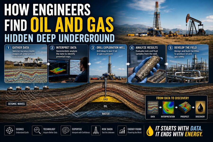
A simplified exploration sequence might look like:
Regional geology → gravity and magnetic surveys → seismic imaging → geological interpretation → exploration drilling → well logs and cores → fluid testing → reservoir modeling
Each step reduces uncertainty.
The seismic data may suggest a trap.
The well confirms the rock type.
The logs indicate porosity and possible hydrocarbons.
The core reveals permeability.
Fluid samples prove what is actually inside the pores.
Only after combining these pieces can engineers confidently understand the reservoir.
🌟 Final Thoughts
Finding oil and natural gas deep underground is one of the clearest examples of how engineering allows humans to investigate places they cannot directly see.
Exploration teams use geology to understand Earth’s history, geophysics to image underground structures, drilling to obtain direct evidence, and computer modeling to reconstruct the reservoir in three dimensions. 🛢️🌍
They are essentially solving a gigantic scientific puzzle.
A seismic reflection might reveal the shape of a hidden rock layer.
A core sample may show whether that rock contains connected pores.
A well log can suggest whether those pores contain water, oil, or gas.
Pressure measurements can reveal whether distant parts of the reservoir are connected.
And computer simulations can predict how the reservoir might behave over time.
Despite all this technology, uncertainty never disappears completely. The Earth is extraordinarily complex, and every reservoir has its own geological history.
That is why petroleum exploration is not simply “finding oil.”
It is the science of collecting incomplete clues from kilometers below the surface and using physics, geology, engineering, statistics, and computation to determine what is most likely hidden there. 🔍🧠
In the end, engineers do not literally see underground oil fields with their eyes.
They reconstruct them from echoes, measurements, rock samples, and mathematical models—turning invisible geological structures into detailed scientific maps.