
Imagine looking across a flat desert, an offshore platform, or a forested field. Nothing on the surface may suggest that oil or gas lies thousands of metres below. Yet a drilling rig eventually appears at one carefully selected location, not at random points across the landscape.
That decision can involve years of geological interpretation, seismic imaging, well data, engineering estimates, commercial screening, and environmental planning. Even then, a well can encounter less hydrocarbon than expected—or none at all.
Finding a drilling target is therefore not like locating a buried pipe with a detector. It is closer to assembling a three-dimensional puzzle from indirect clues, while accepting that the final answer is only revealed when the drill bit reaches the rock.
This is why petroleum engineering works so closely with geology and geophysics. Engineers need to know not only where hydrocarbons may be, but whether a well can reach them safely, produce them effectively, and do so responsibly.
🧭 Drilling Begins With a Subsurface Question
The first question is rarely “Where should the rig go?” It is usually: where could a working petroleum system exist? A petroleum system includes a source rock that generated hydrocarbons, pathways for migration, a reservoir rock to store them, a seal to stop escape, and a trap where fluids can accumulate.
If one essential element is absent, a promising-looking structure may not contain a commercial accumulation. The early search is therefore an exercise in reducing uncertainty about each element.
🌍 The Rocks Tell a Long Geological Story
Oil and natural gas form, migrate, and become trapped over geological time. Sedimentary basins—areas where layers of sediment accumulated and were buried—are the principal places engineers and geoscientists investigate.
Rock layers record changing environments: rivers may leave sand, quiet lakes may leave fine mud, and shallow seas may deposit limestone. Understanding that history helps teams predict which layers might be porous reservoirs, organic-rich source rocks, or sealing shales.
🪨 Source Rock Is the Starting Point
A source rock is commonly a fine-grained shale or mudstone containing preserved organic material. With sufficient burial, temperature, and time, that material can generate oil, gas, or both.
Generation alone does not create a field. Hydrocarbons must leave the tight source rock and move into a more permeable pathway or reservoir. Geochemical analysis of rock samples and oils can help connect discovered fluids to likely source intervals.
🧽 Reservoir Rock Needs Pores and Flow Paths
A reservoir is not usually a giant underground cavern full of liquid. More often, oil, gas, and water occupy microscopic pore spaces between mineral grains or within fractures.
Porosity describes how much pore volume rock contains. Permeability describes how readily fluids can flow through connected pores. A rock may have reasonable porosity but poor permeability if its pores are poorly connected.
Sandstones and some limestones are common reservoirs, but their quality can vary sharply over short distances. That variation is one reason a well location must be selected with care.
🧱 Seals Keep Hydrocarbons From Escaping
Hydrocarbons are generally less dense than formation water, so they tend to migrate upward when pathways exist. A seal is a low-permeability layer, often shale, salt, or dense carbonate, that blocks that movement.
A good reservoir beneath a poor seal may contain little recoverable hydrocarbon. Teams examine the thickness, continuity, fracture risk, and displacement capacity of a potential seal rather than simply assuming every shale layer will work.
⛺ Traps Create a Place to Accumulate
A trap is the geological configuration that allows hydrocarbons to collect beneath a seal. In a simple structural trap, folded rock forms an arch, and hydrocarbons accumulate near its crest beneath an impermeable layer.
Stratigraphic traps are more subtle. They can form where a porous sandstone pinches out into impermeable shale, where a reef changes laterally into tighter rock, or where erosion truncates a reservoir beneath a seal.
| Trap type | What creates it | Typical interpretation challenge |
|---|---|---|
| Structural | Folds, faults, or salt movement | Mapping depth and fault sealing |
| Stratigraphic | Changes in rock type or depositional geometry | Predicting reservoir extent |
| Combination | Both structure and rock-property change | Integrating several uncertain controls |
📚 Basin Studies Narrow the Search Area
Before acquiring detailed data, teams study regional maps, outcrops, older wells, gravity and magnetic surveys, and published geological work. The objective is to understand basin formation, sediment pathways, burial history, and known petroleum occurrences.
This regional stage can identify “play concepts”: repeatable combinations of reservoir, seal, source, and trap that may occur across an area. A play is not a discovery; it is a reasoned geological opportunity.
🔊 Seismic Surveys Image the Subsurface
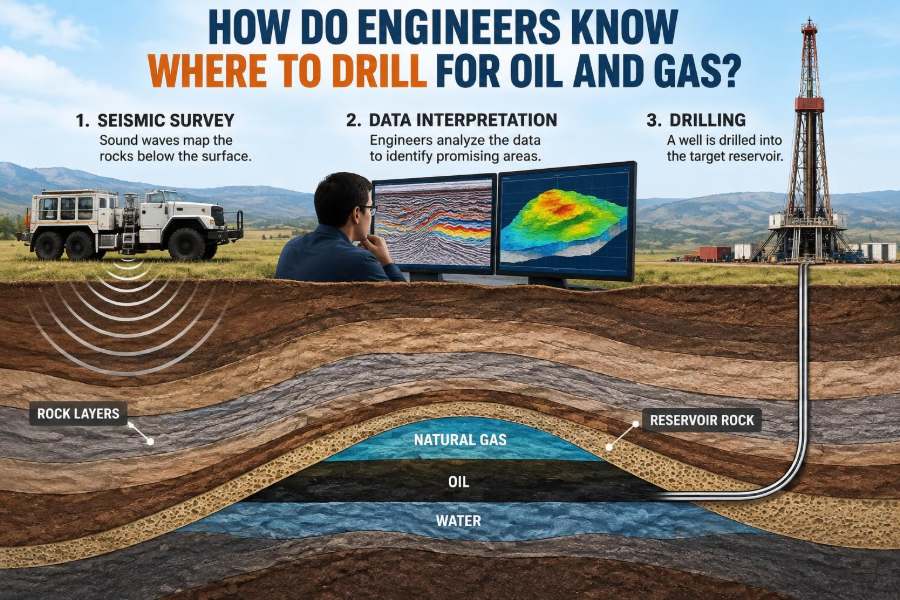
Seismic reflection surveying is one of the most important tools for choosing exploration well locations. Controlled energy is sent into the ground or water, and sensors record returning waves reflected from boundaries between rocks with different physical properties.
Those travel times are processed into images of layered subsurface structure. Offshore, air guns and hydrophones are commonly used. On land, vibrator trucks or other suitable sources and arrays of sensors may be used.
Seismic does not take a literal photograph of oil. It provides indirect evidence about rock boundaries, faults, geometry, and sometimes fluid-related effects.
📐 From Seismic Time to Drilling Depth
Seismic reflections are initially displayed in two-way travel time: the time for a wave to travel down to a boundary and return. A drilling plan, however, needs depth.
Converting time to depth requires a velocity model, because seismic waves travel at different speeds through different rocks. Errors in velocity can shift an interpreted target vertically or laterally, particularly beneath complex salt bodies or strongly deformed geology.
This is why a crisp seismic feature is not automatically a precise drilling coordinate.
🖥️ Why 3D Seismic Changed Target Definition
Older two-dimensional seismic lines are valuable but can leave ambiguity between line crossings. Three-dimensional seismic samples an area much more densely, allowing interpreters to map horizons, faults, channels, and closures in three dimensions.
Better spatial coverage can improve well placement, especially for irregular traps. It also produces large datasets that demand careful processing and interpretation; more data does not eliminate geological uncertainty.
🌈 Amplitudes Can Offer Clues, Not Proof
The strength and character of a seismic reflection may change where rock and fluid properties change. Interpreters may study amplitude, frequency, phase, and variation with offset—the change in response at different source-receiver distances.
Some patterns can be consistent with gas-bearing sand, a fluid contact, or a particular reservoir type. But lithology, tuning effects, processing choices, and pressure changes can create similar appearances. A seismic anomaly is a hypothesis to test, not proof of hydrocarbons.
🧪 Rock Physics Connects Waves to Reservoir Properties
Rock physics provides the framework for relating seismic velocities and densities to mineral composition, porosity, pressure, and fluid saturation. It helps teams ask whether an observed response is physically plausible for the reservoir model.
Because several conditions can produce similar seismic signatures, rock-physics models are calibrated against well logs, core measurements, and local geological knowledge whenever possible.
🕳️ Existing Wells Are Valuable Control Points
Nearby wells provide direct observations that seismic alone cannot. They reveal actual rock types, fluid shows, pressures, reservoir quality, and formation depths at specific locations.
A dry well is not necessarily useless. It may show that a reservoir is water-bearing, that a seal failed, or that a structure was mapped too shallow. Such evidence can refine the next prospect—or rule out an entire idea.
📊 Well Logs Turn a Borehole Into Data
After a well is drilled, logging tools measure formation properties along the borehole. Common measurements include natural gamma radiation, electrical resistivity, density, neutron response, sonic travel time, and borehole geometry.
For example, low gamma-ray readings may suggest cleaner sand rather than shale, while resistivity can help distinguish hydrocarbon-bearing intervals from saline-water-bearing intervals. Interpretation requires multiple logs and local calibration; no single curve gives a complete answer.
🧰 Core Samples Show the Rock Directly
Coring retrieves cylindrical samples of rock from selected intervals. Core can reveal grain size, sedimentary structures, fractures, oil staining, pore types, and features too small for seismic resolution.
Laboratory tests may measure porosity, permeability, capillary pressure, wettability, and mechanical strength. Core is expensive and only samples limited depths, but it is often essential for calibrating broader interpretations.
🧭 Geological Models Combine Disparate Evidence
Geoscientists build three-dimensional models that combine seismic surfaces, faults, well markers, facies interpretations, and petrophysical properties. A facies is a body of rock with characteristics reflecting a particular depositional environment, such as a river channel or shoreline.
The model is never a perfect replica of the subsurface. It is a structured representation of the best current interpretation, with assumptions made visible so they can be tested.
🎲 Uncertainty Is Quantified, Not Wished Away
Exploration teams often describe uncertainty ranges for reservoir area, thickness, porosity, hydrocarbon saturation, fluid type, and recovery. Multiple geological realizations may be generated to represent credible alternatives.
Probability is useful because a prospect can be uncertain in several independent ways. A large mapped closure is not enough if reservoir presence, charge, or seal effectiveness remains doubtful.
💧 Contacts and Pressure Define the Fluids
In many reservoirs, gas, oil, and water arrange themselves according to density and pressure conditions. The boundary between oil and water, for example, is called an oil-water contact.
Pressure measurements and fluid samples can help determine whether a reservoir is connected, compartmentalized by faults, or affected by production from nearby fields. Predicting fluid contacts before drilling matters because a small depth error can move a planned well from oil-bearing rock into water-bearing rock.
🧮 Estimating Volumes Is Not the Same as Estimating Recovery
Volumetric estimates begin with gross rock volume, then apply factors such as net reservoir thickness, porosity, hydrocarbon saturation, and formation volume behaviour. This gives an estimate of hydrocarbons initially in place.
Only a fraction may be technically and economically recoverable. Recovery depends on fluid properties, drive mechanisms, permeability, well design, pressure support, facilities, and operating constraints. A large volume in the ground does not automatically justify drilling.
💼 Commercial Screening Changes the Decision
Before committing to a well, teams consider drilling cost, water depth or terrain, infrastructure distance, likely flow rates, processing needs, market access, and abandonment obligations. A remote gas discovery may require very different economics from an oil accumulation near existing pipelines.
Economic evaluation should be updated as technical understanding changes. It is not separate from subsurface work: a target’s size, fluid type, and uncertainty directly affect whether it is viable.
🌱 Environmental and Community Constraints Matter Early
Location selection also considers sensitive habitats, water resources, fisheries, protected areas, cultural sites, land access, noise, traffic, and emergency response. These are not issues to postpone until a rig is booked.
A technically attractive surface location may be unsuitable, while directional drilling from a different pad may reduce surface disturbance. Requirements vary by jurisdiction, and project planning must follow applicable permits, regulations, and stakeholder processes.
↘️ Directional Drilling Separates Surface and Target
Modern wells are often intentionally deviated. Engineers can drill vertically for part of the well and then build angle, steer laterally, or place a long horizontal section within a thin reservoir.
This flexibility allows one surface location to reach multiple subsurface targets, avoid surface obstacles, and improve reservoir exposure. It also increases planning demands: torque and drag, hole cleaning, casing design, collision avoidance, and geomechanical stability all become more complex.
📡 Geosteering Adjusts the Plan While Drilling
In thin or laterally variable reservoirs, measurement-while-drilling and logging-while-drilling tools provide near-real-time information about inclination, azimuth, gamma ray, resistivity, and other properties.
Geosteering teams use those measurements with the geological model to keep a horizontal well within the desired rock interval. This is not blind remote control; it is a continuous comparison between predicted geology and observed data.
⚙️ Drilling Engineering Tests Whether the Well Is Buildable
Even a compelling target cannot be drilled safely with an unrealistic well design. Drilling engineers evaluate pore pressure, fracture gradient, expected temperatures, troublesome formations, casing points, drilling-fluid requirements, and well-control barriers.
The safe operating window between formation pressure and fracture pressure can be narrow. If mud weight is too low, formation fluids may enter the well; if too high, the formation may fracture and lose circulation. These risks influence trajectory and target selection.
🧯 Safety Barriers Are Part of Location Planning
Well planning includes equipment, procedures, and trained personnel designed to prevent uncontrolled flow and manage hazards. Blowout preventers, drilling-fluid monitoring, casing and cement programs, pressure testing, and emergency plans are parts of a barrier-based approach.
Subsurface uncertainty is never an excuse to relax controls. In fact, uncertain pressure, shallow gas, or difficult formations require more cautious assumptions and contingency planning.
🔍 An Exploration Well Is a Test of a Model
The first well drilled into a prospect is often called a wildcat or exploration well. Its result tests several linked predictions: depth, structure, reservoir presence, fluid type, pressure, and deliverability.
A discovery may lead to appraisal wells, which reduce uncertainty about field size, reservoir continuity, and development options. Conversely, a noncommercial result may still yield information that improves the regional understanding.
🚫 Common Reasons a Promising Prospect Fails
Prospects fail for many reasons, and the failure mechanism matters. A “dry hole” is not one uniform outcome.
- The reservoir rock may be absent, too thin, or too tight to flow economically.
- Hydrocarbons may never have reached the trap, or may have leaked away.
- The trap may be smaller or deeper than interpreted.
- The reservoir may contain water rather than oil or gas.
- Fluids may be present but volumes, flow rates, or development costs may be unattractive.
Post-well analysis should compare predictions with evidence rather than merely label the outcome a success or failure.
🧠 Beware of Overconfidence in Colorful Maps
Seismic maps and reservoir models can look precise because they use smooth surfaces, contours, and colour scales. Their visual clarity can conceal uncertainty in velocities, fault interpretation, fluid contacts, or rock-property prediction.
Good technical decisions make assumptions explicit, consider alternative models, and invite challenge from different disciplines. The most persuasive image is not necessarily the most reliable interpretation.
🤝 Teamwork Connects Geology, Engineering, and Operations
Drilling location decisions are multidisciplinary. Geologists describe depositional and structural history; geophysicists interpret seismic data; petrophysicists evaluate logs; reservoir engineers assess fluids and recovery; drilling engineers design the well; and environmental, safety, commercial, and operations specialists shape what can responsibly be executed.
Conflicting views are normal and useful when they reveal a hidden assumption. A robust plan is not one where everyone starts with the same answer, but one where evidence has been tested across disciplines.
🗺️ A Simple Hypothetical Example
Consider a hypothetical offshore basin where 3D seismic maps a domed sandstone layer beneath thick shale. A nearby well confirms that the sandstone is porous, while geochemical evidence supports a mature source rock deeper in the basin.
The team still must determine whether the dome is sealed, whether the sandstone is continuous, and where the oil-water contact might lie. They may place the first well near the predicted crest but below the seal, while designing the trajectory to collect critical pressure and fluid data.
If the well finds oil but less reservoir thickness than expected, an appraisal well might test the flank. If it finds water, the team would reconsider contact depth, fault compartments, and whether the seismic structure truly represents closure.
🎓 What Students Should Learn From the Workflow
The central skill is not memorizing one tool or one map pattern. It is learning how each measurement constrains a different part of the geological and engineering problem.
- Ask what observation supports a conclusion.
- Separate measured data from interpreted assumptions.
- Recognize the scale of each tool: core is detailed but local; seismic is broad but indirect.
- Consider technical feasibility, safety, environmental effects, and economics together.
- Communicate uncertainty clearly instead of hiding it behind a single estimate.
✅ The Core Principle: Drill Where Evidence and Execution Meet
Engineers do not “know” with certainty where oil and gas are before drilling. They develop the best defensible location by integrating evidence about the petroleum system, reservoir, trap, fluids, well path, safety limits, and project context.
The strongest target is not simply the largest bright feature on a seismic display. It is a location where the geological case is credible, uncertainty is understood, the well can be engineered safely, and the potential outcome justifies the impacts and investment.
Choosing where to drill is disciplined risk management: turning incomplete subsurface clues into a testable, responsible well plan. 🛢️🧭