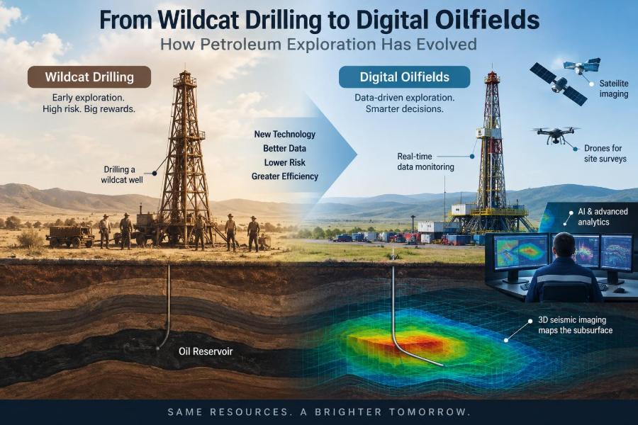

A century ago, petroleum exploration could begin with a rumor, an oil seep, and a drilling crew willing to take a costly chance. A well drilled beyond established production was called a wildcat, and success depended as much on field judgment and persistence as on the limited evidence available.
Modern exploration teams still face uncertainty, but their decisions now draw on seismic imaging, well logs, satellite observations, reservoir models, and continuously updated operational data. The target may lie several kilometers below the surface, yet engineers can build a detailed interpretation before a bit ever turns.
This change matters far beyond finding oil and gas. Better subsurface understanding can reduce unnecessary wells, improve safety planning, protect water-bearing formations, and help operators evaluate whether a prospect fits technical, economic, and environmental constraints.
The story is not one of intuition being replaced by computers. It is a story of better questions, better measurements, and better decisions under uncertainty. Petroleum exploration has evolved from reading surface clues to integrating a vast, imperfect digital picture of the subsurface.
🧭 The enduring challenge of finding hydrocarbons
Exploration seeks accumulations of oil or natural gas that can be produced safely and economically. Hydrocarbons are not spread evenly through the Earth; they occupy particular geological settings created over millions of years.
An exploration team must answer several linked questions: Were hydrocarbons generated? Did they migrate? Is there a porous reservoir rock, an effective seal, and a trap? Did these elements exist at the right times? A favorable answer to only one question does not create a commercial discovery.
🐎 What “wildcat drilling” originally meant
A wildcat well is an exploratory well drilled outside known productive areas or into an untested geological objective. The term captures the uncertainty: the well may open a new petroleum province, or it may find no recoverable hydrocarbons.
Early wildcats often relied on sparse maps, visible seeps, nearby wells, and local geological observations. Those clues were useful, but they could not directly reveal deep structures or fluid contacts. Drilling was therefore a high-stakes way to obtain the first hard evidence.
🪨 Reading clues at the surface
Before modern geophysics, geologists mapped outcrops, rock layers, faults, and topographic patterns. Anticlines—upward folds in rock—became prominent targets because buoyant hydrocarbons can accumulate near their crests when a seal is present.
Surface geology remains valuable, especially in frontier basins and regions with exposed rock. Its limitation is straightforward: rocks at the surface may have been eroded, displaced, or altered, while the prospective reservoir lies far below and may follow a different structural pattern.
🧪 The petroleum system changed the search
The petroleum-system concept shifted exploration from simply looking for structures to evaluating an entire geological chain. A source rock must contain organic material and experience sufficient heat and burial to generate hydrocarbons.
Those fluids must then migrate into a reservoir with connected pore space, remain beneath a low-permeability seal, and be retained in a trap. Timing is crucial. A trap formed after most hydrocarbons escaped is far less promising than a trap that existed during migration.
🔬 Stratigraphy added a deeper dimension
Stratigraphy studies rock layers, their age relationships, and their depositional environments. It helped explorers recognize that reservoirs are not always simple folded layers; they can be ancient river channels, shoreline sands, reefs, submarine fans, or pinch-outs against sealing rock.
This was a major conceptual advance. Some traps are primarily structural, but many are stratigraphic traps, created by changes in rock type or reservoir geometry. Finding them requires understanding how sediments were deposited, not merely how rocks were folded.
🌊 From gravity surveys to reflection seismology
Gravity and magnetic surveys offered early indirect views of the subsurface by detecting variations in physical properties. They remain useful for mapping basin shape, basement structure, salt bodies, and large regional features.
Reflection seismic transformed exploration by recording sound waves that travel into the Earth and reflect from boundaries between rock layers. Processing these signals produces an interpretable image of subsurface geometry, much like using echoes to infer the layout of a dark room.
📡 How a seismic survey becomes an image
On land, controlled vibration sources or carefully managed energy sources generate seismic waves; offshore, specialized vessels commonly use acoustic sources. Receivers measure returning signals at many locations, creating a large data set rather than a single underground snapshot.
Processing corrects and organizes the recorded signals to estimate reflection times and positions. The result is not a literal photograph. It is an interpretation influenced by velocity assumptions, noise removal choices, acquisition geometry, and the geological complexity of the area.
🧊 Why 3D seismic changed prospect definition
Two-dimensional seismic provides vertical slices through the subsurface. It can identify broad structures, but features between survey lines may be missed or misrepresented. A 3D survey samples an area more densely, allowing interpreters to track horizons and faults in multiple directions.
This improved the definition of fault blocks, channel systems, salt-related structures, and subtle closures. It did not remove risk, but it often made prospect boundaries and drilling locations more defensible than decisions based on widely spaced 2D lines.
🕰️ Time, depth, and velocity uncertainty
Seismic reflections are initially recorded in travel time, often milliseconds, while drilling plans require depth. Converting time to depth depends on seismic velocity: the speed at which sound travels through different rocks.
Velocity varies with lithology, compaction, pressure, and fluid content. Incorrect velocity models can place a predicted reservoir too shallow, too deep, or in the wrong structural position. Depth uncertainty must therefore be carried into well planning rather than hidden behind a precise-looking map.
🧱 Seismic interpretation is not a certainty machine
A bright seismic amplitude may indicate a fluid effect, but it can also result from changes in rock properties, tuning effects, processing choices, or other causes. Likewise, a weak or disrupted reflection can arise from geology, poor data quality, or imaging limitations.
Good interpreters test competing explanations. They combine seismic character with well control, regional geology, rock physics, and realistic uncertainty ranges. Treating every colorful seismic attribute as direct proof of hydrocarbons is a costly and common mistake.
🪵 The drill bit still provides the decisive test
Despite increasingly sophisticated models, a well is the direct test of a subsurface prediction. Drilling provides cuttings, cores, pressures, fluid samples, and logs that can confirm or challenge the pre-drill interpretation.
A dry hole is not necessarily wasted information. It can show that the reservoir is absent, the seal failed, hydrocarbons were not generated, or the trap was not charged. Capturing that lesson improves the next decision; ignoring it can repeat the same geological error.
📏 Well logs turn boreholes into measurements
Well logs are continuous measurements collected along a borehole. Gamma ray logs help distinguish shale-rich intervals from cleaner sands or carbonates, while resistivity logs can help assess whether pore spaces contain conductive formation water or more resistive hydrocarbons.
Density, neutron, sonic, and image logs add information about porosity, lithology, fractures, and bedding. No single log answers every question. Engineers and geoscientists interpret multiple measurements together, calibrated where possible with core and fluid data.
🧫 Core and fluid samples ground the model
Core is a cylindrical rock sample recovered from the well. Laboratory analysis can measure porosity, permeability, grain size, wettability, mineralogy, and other properties that logs estimate indirectly.
Fluid samples help identify oil, gas, water, and contamination from drilling operations. Their composition and pressure behavior influence reserves estimates, facility design, and flow assurance planning. Samples are expensive to obtain, so their value depends on careful acquisition and quality control.
🧭 Directional drilling made targets more accessible
Directional drilling allows a wellbore to deviate intentionally from vertical and reach a target some distance from the surface location. This can access offshore targets from a fixed platform, reach beneath environmentally sensitive areas, or avoid surface obstacles.
Extended-reach wells increase technical demands. Torque, drag, hole cleaning, wellbore stability, and accurate position measurements all become more challenging. The ability to reach a target does not automatically make it the lowest-risk or lowest-cost option.
🛞 Horizontal wells reshaped reservoir access
A vertical well intersects only a limited thickness of reservoir. A horizontal well can remain within a productive layer for a much greater distance, increasing contact with the formation and potentially improving flow.
This approach is especially useful in thin reservoirs and unconventional plays with low permeability. Its success depends on precise geosteering, completion design, rock quality, and economics. A long lateral outside the best reservoir interval may underperform despite impressive drilling footage.
🧭 Geosteering uses data while drilling
Measurement-while-drilling and logging-while-drilling tools send or store data gathered near the bit. These measurements can reveal formation direction, resistivity patterns, gamma ray response, pressure indicators, and drilling conditions.
Geosteering teams use this information to guide a well through the planned reservoir window. It is best understood as navigation with incomplete visibility: the team updates a geological model as new evidence arrives, balancing production objectives with well-control and drilling constraints.
💻 The digital oilfield connects fragmented evidence
A digital oilfield is not simply a control room full of screens. It is an operating approach that connects field sensors, drilling data, production history, geological models, equipment records, and workflows so decisions can be made with timely context.
For exploration and appraisal, digital systems make it easier to compare versions of interpretations, share data across disciplines, and recognize inconsistencies before they influence a major decision. The value comes from integration and action, not from data volume alone.
🧠 Machine learning assists pattern recognition
Machine learning can help classify seismic facies, detect faults, identify log patterns, screen large document collections, and flag anomalous equipment behavior. It is particularly useful when teams must review repetitive data at scales that are difficult to manage manually.
Its output is only as dependable as the training data, labels, assumptions, and validation process. A model trained in one basin may not transfer cleanly to another with different geology or acquisition conditions. Domain expertise remains necessary to ask whether a prediction makes geological sense.
🗂️ Data quality is an engineering issue
Digital workflows can amplify errors as easily as insights. Units may be inconsistent, well coordinates may use different reference systems, legacy logs may be poorly scanned, and sensor streams may contain gaps or uncalibrated values.
Useful data governance defines ownership, metadata, quality checks, version control, and access rules. A team should be able to trace a key map, reserve input, or drilling constraint back to its source and understand which assumptions shaped it.
🔄 Integrated teams reduce handoff losses
Exploration decisions cross disciplinary boundaries. Geologists interpret depositional systems, geophysicists image structure, petrophysicists evaluate rocks and fluids, reservoir engineers estimate behavior, drilling engineers design the well, and commercial teams test viability.
When these groups work sequentially with weak communication, crucial constraints arrive late. An integrated team can expose trade-offs early—for example, a geologically attractive target may require a difficult trajectory, while a safer well path may provide weaker reservoir coverage.
📊 Probability replaced single-number thinking
Exploration has always involved uncertainty, but modern workflows increasingly express it explicitly. Instead of presenting one “best” volume estimate as fact, teams may describe ranges and probabilities for reservoir area, thickness, porosity, saturation, recovery, and other inputs.
Probability does not make a prospect safe. It makes assumptions visible and helps decision-makers compare opportunities consistently. A large upside volume with a low chance of geological success is fundamentally different from a smaller target supported by strong well control.
⚖️ Resources, reserves, and commercial reality
Hydrocarbons in the ground are not automatically reserves. Resources describe quantities estimated to exist or potentially be recoverable, while reserves are generally associated with discovered volumes that meet defined technical and commercial criteria under applicable reporting systems.
Exploration teams must consider production rates, development cost, fluid properties, infrastructure distance, market access, regulatory conditions, and abandonment obligations. A discovery can be geologically real yet commercially marginal, especially if it requires complex facilities or has difficult fluid behavior.
🦺 Safety became part of exploration design
Early exploration often accepted risks that modern operations would not. Today, well design considers pressure control, casing and cement barriers, kick detection, emergency response, weather, logistics, and the competence of people performing critical tasks.
A kick is an unplanned influx of formation fluid into a well. Detecting and controlling it promptly is central to well control. Digital monitoring may improve situational awareness, but barriers, procedures, training, and sound judgment remain essential.
💧 Environmental screening starts before drilling
Exploration can affect land, water, ecosystems, communities, and emissions even before production begins. Baseline surveys, route selection, waste planning, spill prevention, noise management, and water protection are therefore part of responsible project design.
Technology can reduce some footprints through smaller pads, directional access, remote monitoring, and better planning. It cannot eliminate all impacts. The appropriate approach depends on local geology, ecology, regulations, infrastructure, and meaningful engagement with affected communities.
🌍 Mature basins and frontier basins need different strategies
In a mature basin, many wells, seismic surveys, and production records may be available. The opportunity is often to identify bypassed pay, deeper targets, overlooked stratigraphic traps, or improved recovery from known fields.
Frontier basins have less direct evidence and usually broader uncertainty. Regional studies, analogs, satellite data, gravity and magnetic surveys, and carefully designed initial wells become more influential. Applying mature-basin confidence to frontier data is a recipe for overinterpretation.
🏭 From discovery to development decisions
A discovery well answers only part of the question. Appraisal wells, pressure data, fluid samples, and additional seismic may be needed to define reservoir continuity, contacts, deliverability, and compartmentalization.
The team then considers development concepts: subsea tieback, platform, onshore gathering system, processing plant, or another configuration. These choices affect which volumes are recoverable, how quickly value may be realized, and what technical risks must be managed over the asset life.
🔍 Common interpretation mistakes to avoid
Several errors recur because they are tempting under schedule pressure:
- Anchoring on a favorite map: treating an early interpretation as settled despite contradictory evidence.
- Confusing a seismic anomaly with a reservoir: forgetting that amplitude is not a fluid sample.
- Ignoring analog limits: assuming a nearby field has identical reservoir behavior.
- Hiding uncertainty: reporting precise depths or volumes without showing the range behind them.
- Separating subsurface and operations: selecting targets without testing drillability and barrier requirements.
The antidote is disciplined peer review, alternate scenarios, and clear documentation of what is known, inferred, and unknown.
🧰 Practical skills for emerging petroleum professionals
Students and early-career professionals benefit from building both technical depth and cross-disciplinary fluency. Learn to read a seismic section, understand basic well logs, explain a pressure-depth plot, and ask how a reservoir model influences a drilling decision.
Equally valuable are data skills: unit checking, scripting or spreadsheet discipline, visualization, database awareness, and reproducible workflows. Strong communication matters because a technically correct conclusion that cannot be understood by operations or management may not improve the decision.
🔐 Cybersecurity is now an operational concern
Connected rigs, sensors, remote operations centers, and shared cloud environments create useful capabilities but also enlarge the digital attack surface. A disrupted data stream can affect planning, monitoring, or business continuity.
Cybersecurity requires more than software tools. Access control, network segmentation, secure vendor practices, backup procedures, incident drills, and awareness of suspicious activity are part of maintaining resilient operations. Data availability, integrity, and confidentiality all matter.
🌱 Exploration’s role in an evolving energy system
Petroleum exploration now operates within changing energy demand, emissions expectations, financing conditions, and policy environments. These factors influence which prospects receive capital and how operators prioritize efficiency, emissions management, and abandonment planning.
Many subsurface capabilities developed in petroleum engineering also apply to carbon storage, geothermal projects, hydrogen storage, and groundwater studies. The rocks do not change, but the project objective, fluids, regulations, and acceptable risks may be very different.
🚀 What the next exploration workflow may look like
Future workflows will likely combine higher-resolution sensing, faster cloud-based interpretation, automated quality checks, real-time drilling data, and more integrated uncertainty models. These tools can shorten feedback loops between prediction and observation.
Yet the most valuable improvement may be cultural: teams that document assumptions, learn quickly from surprises, and challenge attractive narratives constructively. Faster software is helpful only when it supports better geological reasoning and safer operational choices.
🧩 The core lesson: uncertainty must be managed, not denied
From the wildcat era to the digital oilfield, exploration has progressed by adding evidence and improving the way evidence is combined. Surface mapping, seismic surveys, well logs, cores, models, and live data each reveal a different part of the subsurface story.
No tool can eliminate uncertainty because the reservoir cannot be fully observed before drilling and production. The strongest exploration decisions identify the critical unknowns, test them with proportionate data, preserve alternative interpretations, and connect technical promise to safety, environmental, and commercial realities.
Petroleum exploration has evolved from bold guessing toward disciplined, data-informed learning—but its central task remains making responsible decisions about an unseen Earth. That combination of curiosity, technical rigor, and humility will remain essential wherever subsurface resources are evaluated. 🛢️🧭🌍